Created on
Updated on
1494/ Treaty of Tordesilla

Preface: Welcome to this quick recap of the history of immigration of US. Celebrating 250 years of USA.
On the seventh of June, 1494, in a small Castilian town north of Medina del Campo, six men and two teams of geographers finished dividing the surface of the earth in half.
The Treaty of Tordesillas drew a line from pole to pole through the Atlantic, 370 leagues west of the Cape Verde Islands — roughly 46 degrees west, though nobody at the table could have fixed that longitude at sea if their lives depended on it. Everything east of the line belonged to Portugal. Everything west belonged to Castile. Ships were forbidden to sail into the other party's half, with one exception: Castilian vessels could cross Portuguese water in a straight line, so long as they kept going west. The two crowns also agreed not to run to the pope for help against each other — only to ask him, afterward, to bless what they had already decided.
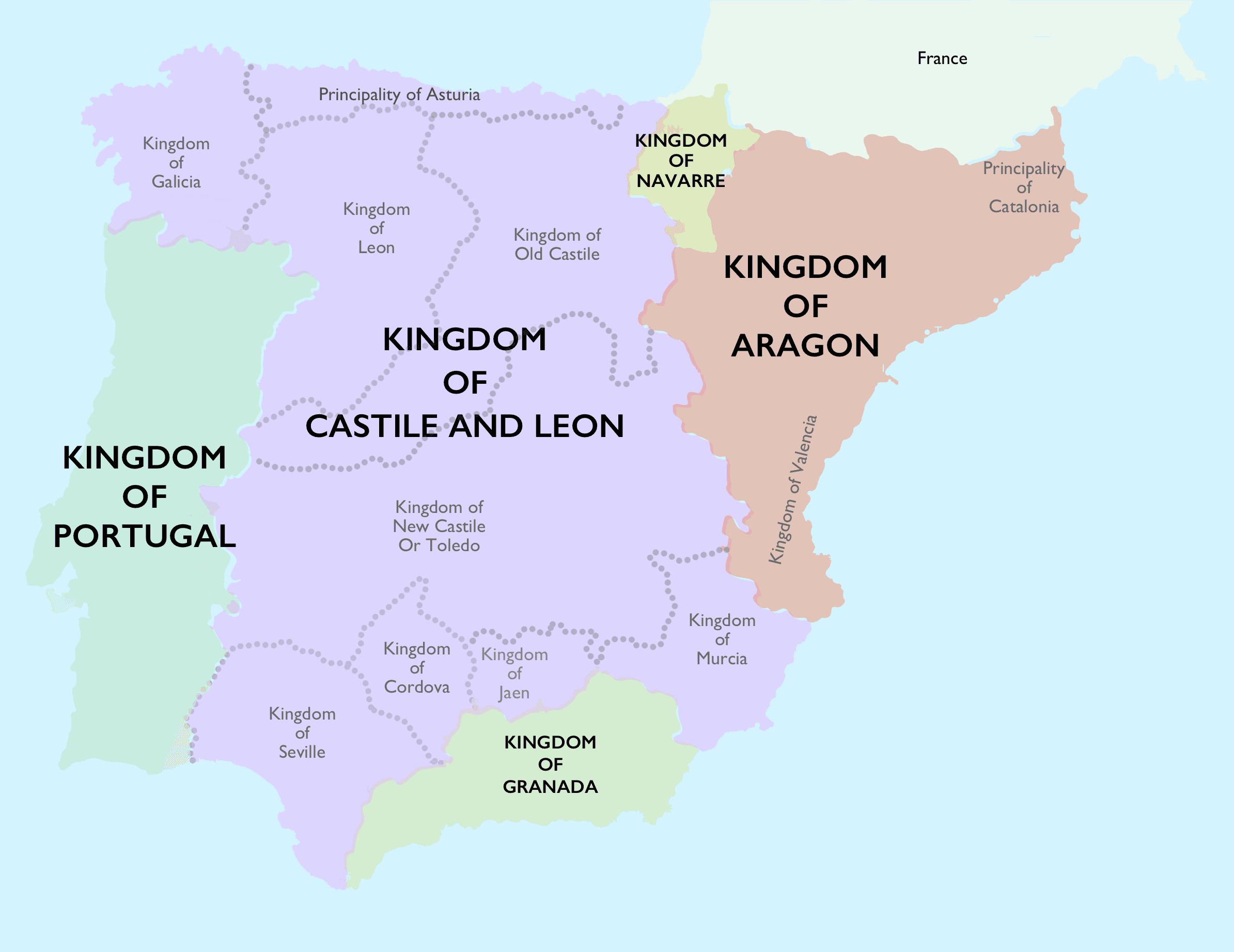
It is usually described as a treaty between Spain and Portugal. To be exact, at the time Spain did not exist yet. Isabella and Ferdinand had wed in 1469, and the union that resulted was personal, not political — two crowns worn by two people who happened to share a bed and a set of enemies. Castile and Aragon kept their own parliaments, their own coinage, their own laws, their own customs houses on the border between them. An Aragonese merchant was a foreigner in Seville. Ferdinand's name appears on the treaty because he was Isabella's husband; the territory being divided was Castile's and Castile's alone.
Columbus had sailed under the Castilian crown, the Indies would be "legally" Castilian property for the next two hundred years, and Aragon — busy with Naples, facing the wrong ocean — was excluded from the New World it is now assumed to have discovered. Granada, the last Muslim kingdom on the peninsula, had surrendered twenty-nine months earlier. Navarre would not be annexed for another eighteen years. The country signing away half the planet was less than three years old and not yet a country.
Portugal, on the other hand, had been a continuously governed state since 1139. It finished its own reconquest in 1249, ran out of frontier, and turned to the water — Ceuta in 1415, then fifty years of grinding, incremental, state-funded work down the African coast under Henry the Navigator, a program that outlived the man who started it. Portugal built the instruments, the ships, the tables, the method of getting back. Castile spent those same decades in aristocratic civil war, with a king so weak history nicknamed him the Impotent (Enrique IV of Castile). It arrived at the ocean late, took one enormous bet on a Genoese (Christopher Columbus) with bad arithmetic, and won. Portugal didn't miss the opportunity through timidity; it declined because its institutional expertise was good enough to detect a fraud. Castile eventually said yes in 1492 for reasons that had nothing to do with the geography being sound — Granada had just fallen, the crown had an army with nothing to do and a surplus of confidence, and the sum involved was small enough to lose.
1493 / Christopher Columbus
Columbus, returning in March 1493, was blown into Lisbon before he could reach Spain — so João II (João II of Portugal — reigned 1481 to 1495) heard the news first, from Columbus himself, and immediately claimed the discoveries were Portuguese. He had a decent case. The Treaty of Alcáçovas (1479) and the bull (a papal bull is a formal written decree issued by the pope — the heaviest instrument in the medieval Church's paperwork) Aeterni regis (1481) had given Portugal everything south of the Canaries, and the 1481 bull is precisely what the later dispute was framed against.
Ferdinand and Isabella went straight to Rome. The pope was Alexander VI — Rodrigo Borgia, Valencian by birth, elected in 1492 with heavy Spanish backing and owing favors accordingly. Over the spring and summer of 1493 he issued a series of bulls, the key one being Inter caetera (May 1493), which drew a line 100 leagues west of the Azores and Cape Verde and granted Castile everything beyond it. A later bull that autumn went further still, arguably handing Castile a westward route to Asia itself.
João II refused it. He had a fleet, he implied he might use it, and he demanded direct talks instead of accepting a ruling from a pope he considered bought. The Castilians agreed — they had what they wanted and no appetite for a war. Both delegations met at Tordesillas in early June 1494.
June 1494 / Tordesillas
The papal line of 1493 had been drawn 100 leagues west of the Azores and Cape Verde. Portugal could not accept it, for two reasons.
The first was that the bull was ambiguous. It said the line ran "100 leagues west of any of the islands of the Azores or the Cape Verde islands." But the Azores sit at 37 to 40 degrees north, and Cape Verde at 15 to 17 degrees north — more than two thousand kilometers apart. A single meridian could not run 100 leagues west of both. The bull left the choice of reference island open. Any careful Portuguese reading of it produced two possible lines several degrees of longitude apart.
The second reason was practical. A line only 100 leagues off Cape Verde ran through the water Portuguese ships needed for the volta do mar — the wide swing into the South Atlantic that any Cape-bound fleet had to make to catch the westerlies home. Bartolomeu Dias had rounded the Cape of Good Hope in 1488. Vasco da Gama would sail three years after Tordesillas. Portuguese pilots already knew the return route required a swing far into open water that the papal line had just given to Castile. This was the technical objection João II led with, and no Castilian pilot could deny it.
So Portugal came to the table asking for 370. Not 200, which would have covered the volta with margin. On a modern map, that puts the line at roughly 46°37' west — a meridian that slices through the eastern bulge of South America. What the extra distance bought Portugal, in navigational terms, was a comfortable corridor for its Cape-bound fleets. Portugal may not have picked 370 just for navigation. They may have picked 370 because they already suspected there was land out there and wanted the line drawn far enough west to include it. Six years later, Cabral "accidentally" made landfall on a coast that turned out to fall right inside the zone the treaty had already given to Portugal. That's either an astonishing coincidence, or evidence that Portugal knew what it was doing in 1494.
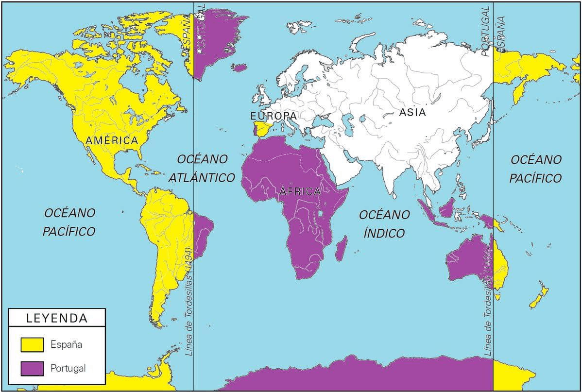
To trace the 370-league line on a modern atlas: it enters South American waters north of the Amazon delta, coming ashore just east of the modern city of Belém, which sat on the Castilian side by a whisker. It runs south through the eastern edge of the Amazon basin, just west of modern Brasília. It crosses the interior and the state of São Paulo — the city of São Paulo sits at 46°38' west, essentially astride the line. It reaches the Atlantic near the town of Laguna, in Santa Catarina, where a stone marker still commemorates the landing point. Everything east of that trace was Portuguese. Everything west was Castilian.
In practice, Portuguese Brazil was a coastal strip. The great cities of colonial Brazil — Salvador, Recife, Fortaleza, Rio de Janeiro, and the whole seaboard south to Laguna — all sat east of the line, on the Portuguese side, with hundreds of kilometers of margin. This is the strip the Portuguese crown began to occupy in the 1530s under the capitanias hereditárias system. What was not Portuguese under Tordesillas is most of the country a modern reader would call Brazil: the Amazon basin from Manaus to the Andes, the vast interior of Mato Grosso, Goiás, Rondônia, Acre, and the Rio de la Plata basin. Portuguese Brazil in 1494 was perhaps a third of the modern country, arranged as a long thin arc along the sea. The rest, Portugal took later, without treaty authority, by simply settling it.
Six men signed. For Castile: Enrique Enríquez de Guzmán, Gutierre de Cárdenas, and Rodrigo Maldonado — the royal Mayordomo Mayor, the Contador Mayor and Comendador Mayor of Santiago, and a jurist of the royal council known as Doctor Talavera. For Portugal: Ruy de Sousa, his son João de Sousa, and the jurist Arias de Almadana. Two teams of geographers sat behind them. The negotiations were technical, brief, and — for a document that would allocate two continents — remarkably one-sided in their outcome.
Technical, because what the two delegations were actually arguing about was not principle but measurement. Both sides had already conceded the concept of a north–south meridian dividing an ocean neither could see across; the question that took months to work through was where the meridian sat, in units nobody could agree on, referenced to islands nobody had precisely surveyed. The Iberian legua was not one length but several — the Portuguese league of about 5.5 kilometers ran shorter than the Castilian league of roughly 5.9, and the maritime league used at sea was different again. A number of "leagues" from Cape Verde meant one distance to a Portuguese pilot and a distinguishably different one to a Castilian, and the treaty text did not stipulate which league was meant. Which of the Cape Verde islands the count was to run from was also left open; when cosmographers were later dispatched to actually mark the line, the Castilians measured from San Antonio (the westernmost island) and the Portuguese from Sal (the easternmost), and the two teams never agreed on which one the treaty had meant. Behind the ambassadors sat two teams of geographers, cartographers, and pilots, working with astrolabes, portolan charts, and tables of solar declination, because the terms of the document required judgment on questions of practical navigation that a diplomatic staff could not answer alone. The treaty is one of the first international agreements in European history whose technical annexes were doing more work than its clauses.
Brief, because from formal opening to signature the whole process took about three months. Preliminary contacts had begun in the closing months of 1493. Full negotiations opened at Medina del Campo in March 1494, continued there until 8 May, and were then moved fifty kilometers north to Tordesillas — reportedly to be closer to Isabella, who was recovering from an illness at the time — where they ran for a further month and a half before the final act was signed on 7 June. Three months, to redraw the world. By the standards of the century — the peace negotiations that ended the Italian Wars a generation later would run for decades — this is a fast document. It moved quickly because both sides wanted it to. Isabella and Ferdinand wanted the Portuguese threat off their western border so they could consolidate the Granada campaign and turn to Italy; João II wanted the Cape route protected before Vasco da Gama sailed. Neither side had time for a long negotiation, and neither side treated the specifics of the meridian as if they mattered as much as the fact of a signed agreement.
One-sided, because the concessions did not balance. The Portuguese delegation arrived with a number — 370 leagues — and left with that same number. There is no evidence in the surviving record that the Castilians tried to negotiate it down toward 200 or 250. What Castile received in return was a bundle of confirmations rather than substantive gains: Portuguese recognition of Castilian sovereignty over what Columbus had already reached, a withdrawal of João II's threat of naval action, and a clause committing both crowns to keep the pope out of any future dispute — a small win against Alexander VI that mattered more in that specific moment than it would in the long run. What Portugal received was material and geographic: 270 leagues of additional westward zone, formal protection of the volta do mar, cover for the still-secret Cape route to India, and — as Cabral would demonstrate six years later — legal title to a coastline that João II may have already known was there. The composition of the two delegations helps explain how this outcome was reached. Portugal sent professionals: Ruy de Sousa had led embassies to the Kongo, his son had grown up in a diplomatic household, and Arias de Almadana was a jurist familiar with maritime law. Behind them stood a Portuguese cosmographic establishment that had spent eighty years mapping the Atlantic. Castile sent grandees: Enríquez was a household officer, Cárdenas a treasury official, Maldonado a jurist and rector of Salamanca. None of them were sailors. The Portuguese knew what the numbers meant; the Castilians knew what a signature meant. The asymmetry was not diplomatic incompetence on the Castilian side — Enríquez, Cárdenas, and Maldonado were formidable men, and the terms they accepted served Castile's short-term interests — but it was a mismatch in geographic literacy that let the Portuguese set every technical parameter of the agreement.
(writing)